
國道一路通 - 高速公路即時路況圖及即時影像
by DoItWell Application Ltd (DoItWell.app)
Version 3.5.1a
📅 Updated March 29, 2021
Open the location, which is the car condition map near the center of the location on the actual map, and the map can be zoomed to quickly understand the highway condition. It also provides functions such as front vehicle speed, speed camera detection, real-time monitor image, police radio station, and voice broadcast along the route.
Features 國道一路通 - 高速公路即時路況圖及即時影像
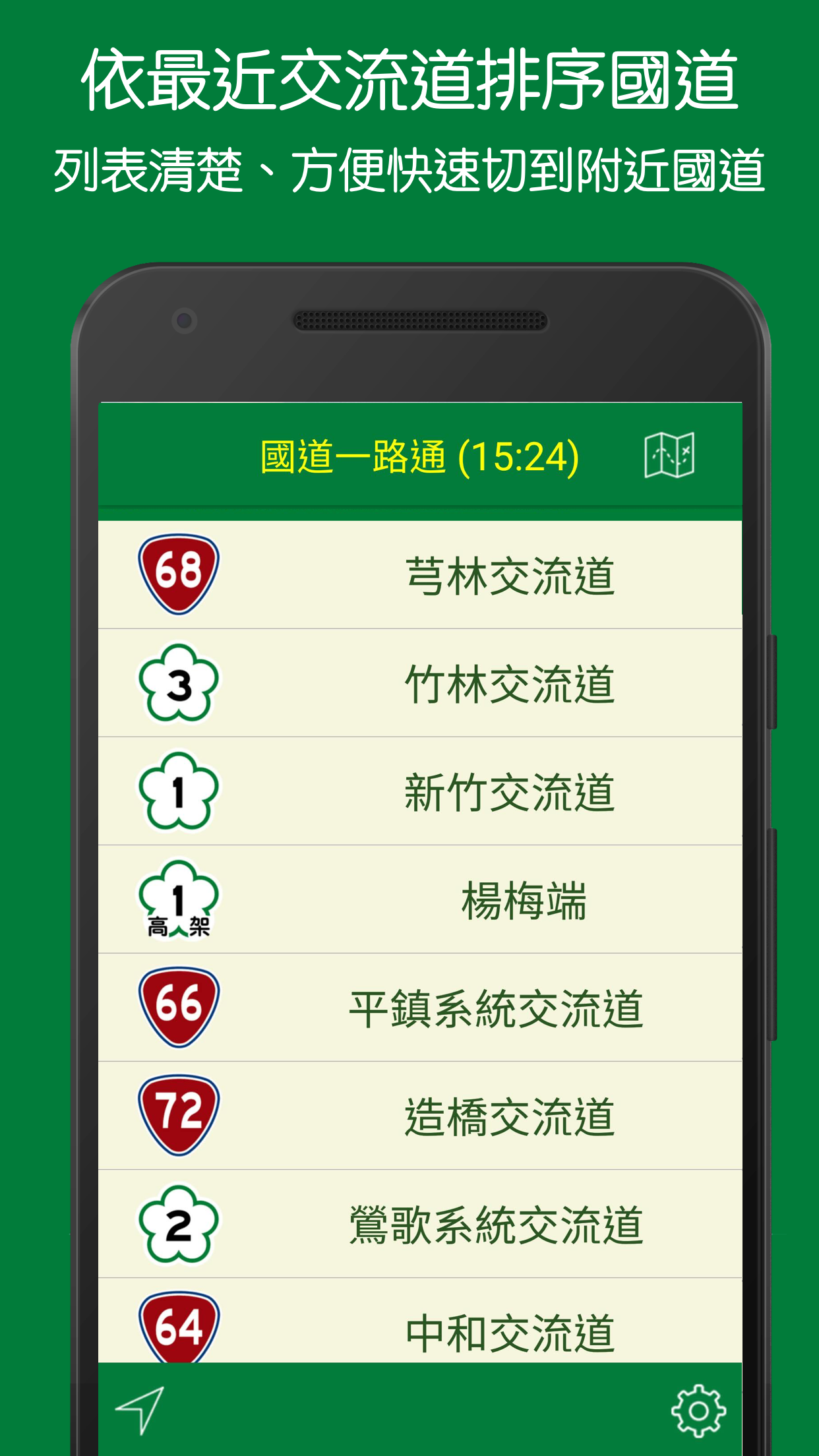
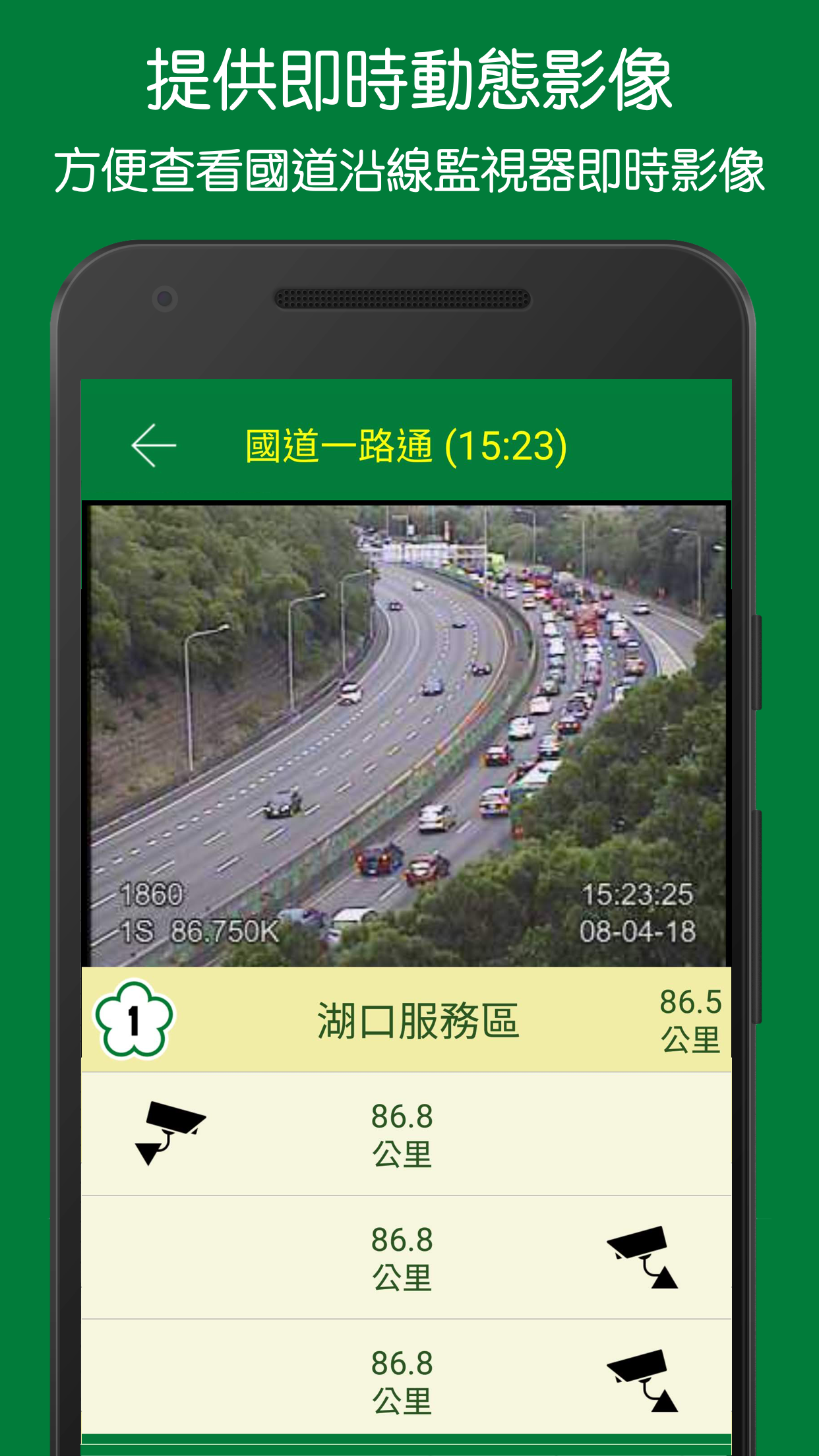
國道一路通 - 台灣高速公路即時影像、塞車狀況、車速查詢以及沿線語音播報打開定位即實際地圖上繪製所在地中心附近的車況圖,可縮放地圖,不再是小小的縮小圖,即時通暢了解高速公路的路況。另提供各國道交流道間的車速、測速照相偵測、即時監視器影像、警廣電台以及沿線語音播報等功能。目前包含路段:各國道、快速道路(台6x, 台7x, 台8x 等)以及台九線蘇澳至楓港路段(蘇花改、花東以及南迴三個路段)主要功能- 打開即用:打開定位即實際地圖上繪製所在地中心附近的車況圖,真正國道路況即時通。- 底圖選擇:地圖採用 Mapbox ,提供「白色底圖」、「黑色底圖」兩種- 地圖縮放:可放大方便了解哪路段附近的交流道回堵,重新開啟時,將依最後觀看比例縮放- 附近匣道:首頁列表依定位座標排列出最近交流道的國道、高速公路,方便找到最近國道- 車速資訊:提供各國道交流道間的車速資訊- 警廣電台:播放警察廣播電台選項設定,預設依定位所在地切換最近的地區警廣電台,可以切換成全國網選項。- 監視影像:提供各國道交流道間的即時監視器(CCTV)影像 - 省電定位:除了一開始的定位,每隔五分鐘才重新定位乙次,並會依座標更新地圖中心所在地- 道路標誌:地圖上標示國道、快速道路標誌 (不包括國1,國3標誌)。可以切換標示警廣路況資訊所在地。- 車速警示:另提供「沿線資訊及車速」模式切換,除以上基本語音播報,包括車速測量功能 ,若超過限速,車速會以紅字提醒,若超過所設定的限速(110%, 105%, 100%) 時,則嗶聲提醒,此功能也可選擇關閉。由於連續定位,基本語音播報功能會更精準,然而,耗電也相對較高,建議同時接上電源(比如隨身電池等)使用。另外,此模式下地圖將自動轉向車子行進方向。- 其他播報:另可設定前方交流道以及前方路段平均車速播報。- 交流道點:地圖上用虛線空心圓圈標示交流道,點擊可查交流道名稱,方便確認塞車路段 (避免和國1混淆,不包括「汐五高架」交流道)- 語音播報:提供沿線資訊播報,包括沿線電子看板(又稱資訊顯示板, CMS)、固定式測速照相、休息服務區以及警廣即時路況。支援背景語音播報功能,可搭配前景其他導航軟體 (比如 Google Map) 使用。*語音播報注意事項 - 開啟語音播報時,定位將由原本五分鐘省電定位,改成一分鐘定位,會比較耗電 - 短時間內連續相同內容者,將不重覆播報 - 避免和國1混淆,播報內容不包括「汐五高架」交流道資訊.
- 由於每分鐘才定位乙次,有些路段相近平行的路段可能會誤判,比如國1 分別和 台72, 台74 相近的路段。 - 若程式判斷十五分鐘內都沒在國道或快速道路上,將自動停止語音播報,節省用電。 - 若覺得語音播報相對於其他音樂聲音太小時,請前往手機的設定,依以下步驟來增強語音音量:語言與輸入設定 >> 文字轉語音輸出 >> Google 文字轉語音引擎 (右邊設定圖示) >> Google 文字轉語音引擎 設定 >> 增強語音音量。圖片說明:https://goo.gl/BL5LQf資料主要來源:- 交通部國道高速公路局 1968路況「交通資料庫」- 交通部公路總局省道交控路側設備資料- 警政署 警廣即時路況資訊若有其他功能需求,或者使用上有問題,可以利用 App 設定內回報給我們。另外,資料來源眾多,難免資料會有錯誤,也可利用 App 設定內回報給我們。 National highways all the way-real-time images of Taiwan highways, traffic congestion, speed query and voice broadcast along the routeTurning on the location is to draw a map of the vehicle conditions near the center of the location on the actual map.
The map can be zoomed and is no longer a small zoomed-out map, and you can instantly understand the road conditions of the expressway.
In addition, it provides functions such as vehicle speed, speed camera detection, real-time monitor images, police radio stations, and voice broadcasts along the highways between national highways.Currently includes road sections: national roads, express roads (Taiwan 6x, Taiwan 7x, Taiwan 8x, etc.), and the Suao-Fenggang section of the Taijiu Line (three sections of Suhuagai, Huadong and Nanhui)The main function-Open and use: Turn on the positioning, that is, draw a map of the vehicle conditions near the center of the location on the actual map, and the real country road conditions are instantly communicated.-Base map selection: Mapbox is used for the map, and two types of "white base map" and "black base map" are provided-Map zoom: you can zoom in to understand which section of the nearby interchange is blocked, and when it is reopened, it will be zoomed according to the last viewing scale-Nearby box roads: The homepage list lists the nearest national highways and highways of the interchange according to the positioning coordinates, so that you can easily find the nearest national highway-Speed Information: Provides speed information between the interchanges of international roads-Police radio station: broadcast police radio station option settings, preset to switch to the nearest regional police radio station according to the location of the location, and can be switched to the national network option.-Surveillance image: Provide real-time monitor (CCTV) images between national highways-Power-saving positioning: In addition to the initial positioning, repositioning is performed only once every five minutes, and the location of the map center will be updated according to the coordinates-Road signs: National highways and express road signs are marked on the map (excluding country 1, country 3 signs).
You can switch to indicate the location of the police and traffic information.-Vehicle speed warning: In addition to the basic voice announcement above, it also includes the speed measurement function.
If the speed limit is exceeded, the speed will be reminded in red.
If the speed limit is exceeded (110%, 105%) , 100%), the beep will remind you, this function can also be turned off.
Due to continuous positioning, the basic voice broadcast function will be more accurate.
However, the power consumption is relatively high.
It is recommended to connect to a power source (such as a portable battery, etc.) at the same time.
In addition, the map will automatically turn to the direction of travel in this mode.-Other announcements: You can also set the average speed announcement for the front intersection and the road section ahead.-Interchange point: Use a dotted hollow circle to mark the interchange on the map.
Click to check the name of the interchange to facilitate the identification of traffic jams (to avoid confusion with China 1, excluding the "Xiwu Elevated" interchange)-Voice broadcast: provide information broadcast along the route, including electronic billboards (also known as information display boards, CMS), fixed speed cameras, rest service areas, and real-time traffic conditions along the line.
Support background voice broadcast function, can be used with other navigation software (such as Google Map) in the foreground.*Notes for voice broadcast -When the voice broadcast is turned on, the positioning will be changed from the original five-minute power-saving positioning to one-minute positioning, which will consume more power -Those who have the same content continuously within a short period of time will not repeat the broadcast -To avoid confusion with country 1, the broadcast content does not include the information of the "Xiwu Elevated" interchange.
-Since the positioning is only once per minute, some road sections that are similar and parallel may be misjudged, such as the road sections where National 1 is close to Taiwan 72 and Taiwan 74.
-If the program determines that you are not on the national highway or expressway within 15 minutes, it will automatically stop the voice broadcast to save electricity.
-If you feel that the voice broadcast is too small compared to other music sounds, please go to the phone settings and follow the steps below to increase the voice volume: Language and input settings >> text-to-speech output >> Google text-to-speech engine (setting icon on the right) >> Google text-to-speech engine settings >> Increase the voice volume.
Picture description: https://goo.gl/BL5LQfMain sources of information:-National Highway and Expressway Bureau, Ministry of Communications 1968 Road Conditions "Traffic Database"-Provincial Highway Traffic Control Roadside Equipment Information-Police station, police broadcast real-time traffic informationIf you have other functional requirements, or use problems, you can report it to us in the App settings.
In addition, there are many sources of information, and it is inevitable that there will be errors in the information.
You can also report it to us in the App settings. 修正一個語音播報時可能造成閃退的問題
Music Features
Enjoy high-quality music streaming and playback features.
Social Features
Connect and share with friends and the community.
Gaming Features
Enjoy immersive gaming experience with various game modes.
See the 國道一路通 - 高速公路即時路況圖及即時影像 in Action

Get the App Today
Available for Android 8.0 and above